Arthur Slowly Meandering off Florida

Tropical Storm Arthur has slowly intensified over the last 24 hours and is forecast to continue to do so over the next 48. As of 11am Wednesday, here is the latest information:

Location: 260 miles SSE of Charleston, SC
Winds: 60 mph
Movement: N @ 7 mph
Pressure: 997 mb

NEW WITH THIS ADVISORY:
A tropical storm WARNING has been issued from Little River Inlet, nc to the NC/VA border
Tropical Storm watch previously in effect for the east coast of Florida is discontinued.

A hurricane watch remains in effect from Bogue Inlet to Oregon Inlet, NC as well as the Pamlico Sound.

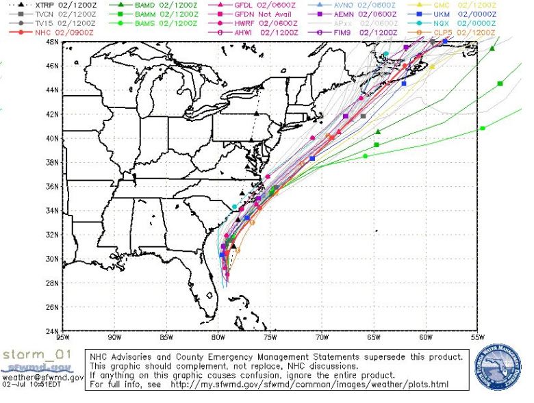
12Z 2014-07-02 Spaghetti Models TS Arthur

12Z 2014-07-02 Spaghetti Models TS Arthur

As seen by the spaghetti models, as well as from my post yesterday, the forecast track is fairly confident. The center of Arthur will pass on or close to the NC Outer Banks Thursday to Friday morning, then exit northeast. MOST places along the coast north of the Outer Banks won’t really see much from Arthur at all – but more from a cold front that will help to push Arthur out to sea. The primary effects of Arthur will be felt very close to the coast up to the Outer Banks. Arthur is expected to be a category 1 hurricane when it does come close to NC.
Arthur Becomes 1st Named Storm of 2014 Season

The first month of the season has gone under our belt with no named storms, but July has changed that right away! Tropical Storm Arthur formed this morning off Florida’s coast and will most likely dampen part of this weekend’s holiday plans for the east coast.

Before you fret, it won’t be an entire weekend washout across the eastern seaboard. Arthur will be gone and out of the way later Saturday. The farther south you are on the coast, the earlier you will be done with impacts from the storm.

Here’s the current information on Arthur as of 2pm Tuesday:

Location: 80 miles ESE of Cape Canaveral, FL
Winds: 40 mph
Movement: NW @ 5 mph
Pressure: 1007 millibars

Spaghetti Models for Arthur's future track. 12Z Tuesday 2014-07-01

Spaghetti Models for Arthur’s future track. 12Z Tuesday 2014-07-01

As you see in the above “spaghetti models” for Arthur’s future track, the forecast is fairly certain. Arthur has begun to move a little more this afternoon towards the NW, but with an approaching frontal boundary, will be steered northward and eventually up the coast. It will be close to, or just over the North Carolina Outer Banks on Friday morning, then accelerate up the Gulf Stream and out to see with the front, and by Sunday – will be off the coast of Nova Scotia.

As for the intensity forecast, that’s a little less certain. Until this morning, Arthur wasn’t all that organized, with very little convection on the northern side of the circulation. Since then, the outflow around the cyclone has gotten better organized and a NOAA hurricane hunter plane is investigating this storm this afternoon. Arthur will be in an area of favorable atmosphere to intensify over the next few days and could become a hurricane by the time it gets near the Outer Banks.

Regardless of what happens over the next couple days, this will not be an inland threat, but rip currents, heavy rain, and gusty winds will be the main impacts along the immediate coasts.