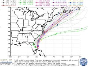
The first month of the season has gone under our belt with no named storms, but July has changed that right away! Tropical Storm Arthur formed this morning off Florida’s coast and will most likely dampen part of this weekend’s holiday plans for the east coast.
Before you fret, it won’t be an entire weekend washout across the eastern seaboard. Arthur will be gone and out of the way later Saturday. The farther south you are on the coast, the earlier you will be done with impacts from the storm.
Here’s the current information on Arthur as of 2pm Tuesday:
Location: 80 miles ESE of Cape Canaveral, FL
Winds: 40 mph
Movement: NW @ 5 mph
Pressure: 1007 millibars
As you see in the above “spaghetti models” for Arthur’s future track, the forecast is fairly certain. Arthur has begun to move a little more this afternoon towards the NW, but with an approaching frontal boundary, will be steered northward and eventually up the coast. It will be close to, or just over the North Carolina Outer Banks on Friday morning, then accelerate up the Gulf Stream and out to see with the front, and by Sunday – will be off the coast of Nova Scotia.
As for the intensity forecast, that’s a little less certain. Until this morning, Arthur wasn’t all that organized, with very little convection on the northern side of the circulation. Since then, the outflow around the cyclone has gotten better organized and a NOAA hurricane hunter plane is investigating this storm this afternoon. Arthur will be in an area of favorable atmosphere to intensify over the next few days and could become a hurricane by the time it gets near the Outer Banks.
Regardless of what happens over the next couple days, this will not be an inland threat, but rip currents, heavy rain, and gusty winds will be the main impacts along the immediate coasts.

Leave a comment